A Few Words About Our Website Home Page Images
On the home page of our website we feature four of the most historically-significant images ever produced of St. John. We believe these renderings help bring to life the incredibly rich history of this very special island. They are:
Coral Bay from the Emmaus Moravian Mission Station, dated 1833, by Robert H. Schomburgk
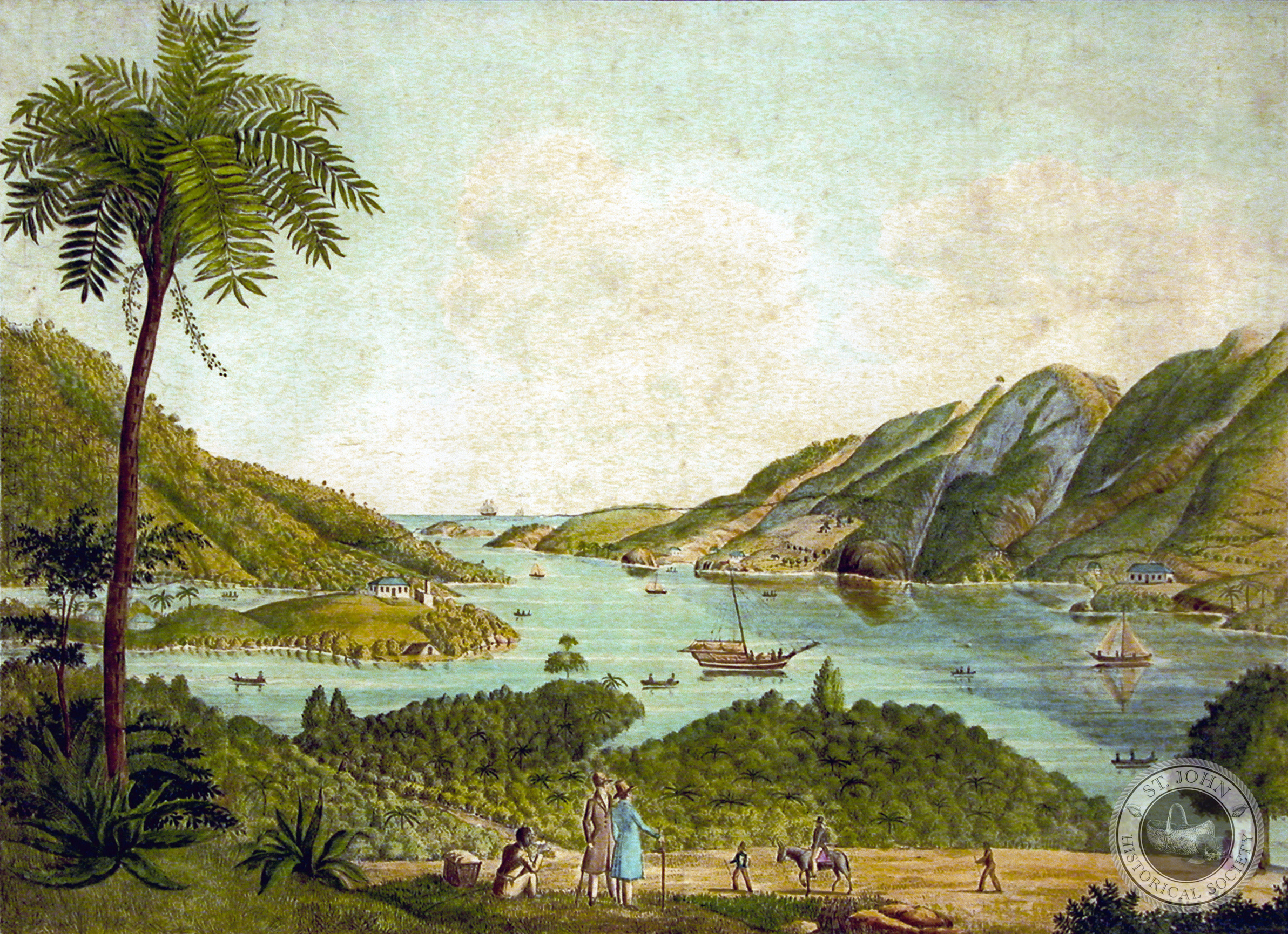 (Lithograph of Coral Bay, from a painting by Robert H. Schomburgk dated1833 [Image courtesy Michael and Jane Sheen Collection])
This spectacular color image of Coral Bay is a print of a rare watercolor painting rendered by Robert H. Schomburgk in 1833. Born in Germany in 1804, Schomburgk was one of a group of European explorers and scientists who surveyed the geography and natural history of the tropics in the 1800s. He resided in the British Virgin Islands and the Danish West Indies from 1825 to 1835. Robert H. Schomburgk is featured in an article by SJHS board member Eleanor Gibney, which appeared in the Society’s newsletter in February 2010. Eleanor’s article can be viewed by clicking here.
The Bethany Moravian Mission Settlement circa 1852, by Levin T. Reichel
 (Lithograph of the Bethany Moravian Mission Station on St. John, from a drawing by Bishop Levin T. Reichel, c1852, and published in Berlin, 1861; printed by Leopold Kraatz [Image courtesy of the D. Knight Collection])
In 1755 construction began on the St. John’s first Moravian Church on a property acquired by The Mission in the Cruz Bay Quarter. The project was overseen by Jens Rasmus, who also supplied the timbers from his own property. The new church, known as “Bethanien” (or, “Bethany” in English), was completed in 1759 and consecrated by Brother Nathanial Seidel on April 29 of that year. Although destroyed many times, the church has always been rebuilt and is still in use to the present day. The Bethany Moravian Church is featured in an article by SJHS board member Robin Swank, which appeared in the Society’s newsletter in February 2009. Robin’s article can be viewed by clicking here.
1780 Manuscript Map of St. John by Peter L. Oxholm
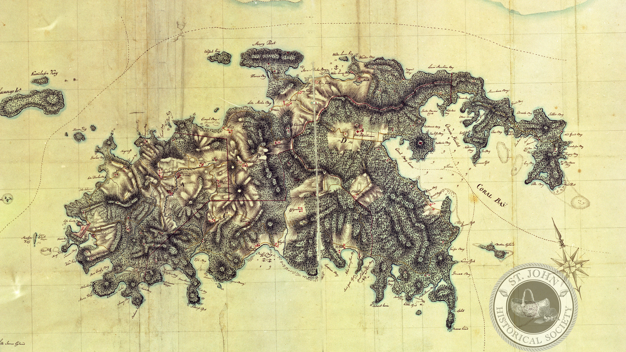 (Photo reproduction from the original manuscript map of St. Jan (in English, St. John) in the Danish West Indies, by Peter L. Oxholm, 1780 [Image courtesy the Statens Arkiver Map Collection, Copenhagen, Denmark])
In 1780, a military engineer by the name of Lt. Peter L. Oxholm was sent to St. John to carry out the seemingly-overwhelming task of producing the first concise map of the island. Oxholm’s resultant rendering brilliantly captures the rugged landscape of what was at the time the least-known part of Denmark’s distant West Indies colony. Not only does the map accurately portray the positioning and ownership of all existing plantations, it also delineates the island’s five administrative districts, referred to until the present day as “quarters.” SJHS member David W. Knight, Sr. co-authored an article on Oxholm’s mapping of St. John, which appeared in the November 2008 Society newsletter. The article can be viewed by clicking here.
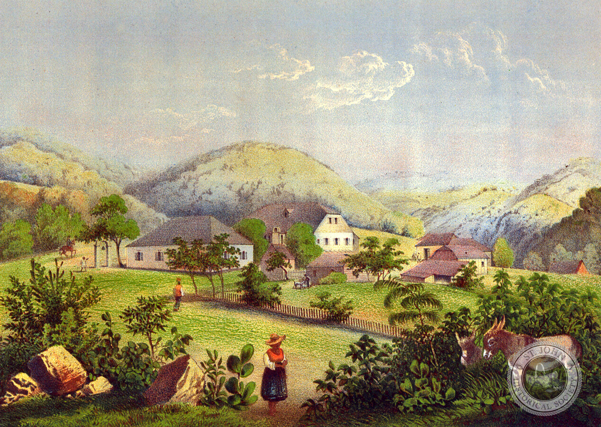
An Overview of the Abraham’s Fancy plantation on St. Jan circa 1852, by Fritz Melbye
 (Photo reproduction from an original oil painting attributed to Fritz Melbye, c1852 [Image courtesy of the D. Knight Collection])
This remarkable circa 1852 overview of the Abraham’s Fancy plantation, with its three grand estate houses of Mount Pleasant, Vanninisberg and America Hill, is attributed to the famed Danish landscape painter Fritz Melbye. Most SJHS members will already be aware of Melbye’s work, most notably his iconic images of the Cruz Bay Battery and a provision grounds on Ajax Peak, which were widely reproduced by Bærentzen & Company and published in a popular Danish national atlas in the 1860s. Born in Elsinore, Denmark, in 1826, Fritz trained as a painter under his older brother, Anton Melbye. In 1849 Fritz set out for the Danish West Indies, eventually settling on the island of St. Thomas. There, he met the young Camille Pissarro, who became his pupil, as well as a long-time friend and traveling companion. After an extended journey through the West Indies and Venezuela, in 1856 Melbye briefly returned to Europe before traveling to North America and setting up a studio in New York City. In 1866, Melbye set off for the Far East on what was to be final adventure. While in Asia he used Peking as a base for travels throughout the region. He died in Shanghai three years later.