EarthQuakes & Tsunamis: Prospects for the Virgin Islands Presented by Roy Watlington and Shirley Lincoln summarized by Robin Swank
(Presented by Roy Watlington and Shirley Lincoln, summarized by Robin Swank)
In 1997 Roy Watlington and Shirley Lincoln published Disaster and Disruption in 1867: Hurricane, Earthquake and Tsunami in the Danish West Indies. It is a significant collection of primary documents–official proclamations, newspaper clippings of Damaged Goods Auctions and Notices of Reconstruction Crews for Hire, original lithographs of the disaster, and chilling personal accounts of survival–describing the cycle of alarm, terror, sorrow, and mending during a brief period of time in 1867.
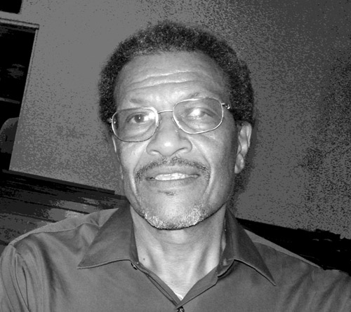
Roy Watlington, our engaging and charismatic
speaker, is a UVI Physics Professor, CaRA
Regional Coordinator and member of the
IOCARIBE Group of Tsunami Experts…
and more.
January 8, 2008 brought both Mr. Watlington and Ms. Lincoln to St. John to share past and future glimpses of tsunamis. Over 50 SJHS members and guests welcomed them to Cruz Bay for an eye-opening educational evening.
St John’s VIERS, Mr. Watlington begins, was the site of a May 1996 Consultation of Experts on Tsunamis, hosted by the UVI’s Eastern Caribbean Center. Caribbean experts at this UNESCO-supported conference created documents that served as impetus for the formation of regional tsunami warning systems and research. “In preparation for this conference, on behalf of the Eastern Caribbean Center, Ms. Lincoln collected accounts of people, culture and events that occurred during natural catastrophes,” Mr. Watlington reported. Some of his ancestors, whether by blood or bondage, showed up in this research, as did many family names still familiar to us in the USVI today.
Mr. Watlington is an engaging teacher, giving us first a primer on plate tectonics. “We sit on a small plate, aggressive as plates go,” he says, showing us how Earth’s tectonic plates fit together, and explaining how the plates jostle past each other or collide, creating friction and giving rise to volcanoes and to earthquakes, which may cause tsunami. “Trenches, island arcs, mountains and volcanoes define the margins of our plate,” he says, displaying how earthquake epicenters clearly mark our plate’s boundaries.
“A tsunami” (Japanese for ‘harbor wave’) “is not the same as a tidal wave.” Mr. Watlington explained the mathematics of tsunami velocity, wave height, and the depth of the quake causing it. He makes it quite clear that this is a large volume of water, miles of water, moving in. You won’t feel the wave far out at sea; the volume of water rising would include the horizon. A wave moves fast; at 4500 meters deep, a tsunami may be moving at almost 500mph. He explained that the sea may recede first, but not necessarily–“don’t hang around to watch the fish flop on the sand,” he advises.
- “The year opened with the population recovering from a cholera epidemic, even as yellow fever claimed lives regularly.” *
- Wooden buildings destroyed by conflagration had been replaced with those of stone and brick to avert the spread of any other fires, leaving earthquake-prone structures in place.
- Mr. Watlington then asked us to look back at the Danish West Indies on November 18, 1867…
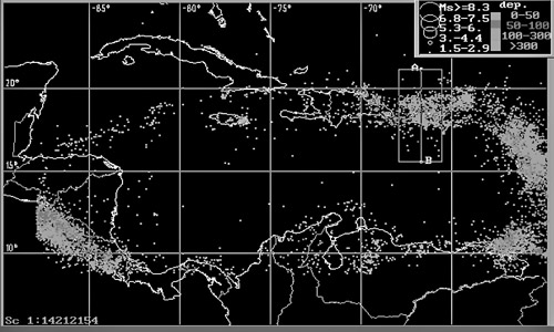
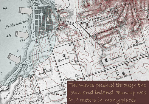
Location of earthquake epicenters reveal the
boundaries of the Caribbean plate
(SOURCE: US Geological Survey)
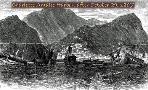
- A hurricane occurring October 29 had claimed numerous local businesses, homes, and about 500 lives. Vessels sank up and down the island chain, including the packet HMS Rhone off Peter Island. There was still much debris in the harbors, some ships with masts barely above water and some massed together with intertwined masts and funnels. (The western peninsula enclosing the Harbor was channeled in 1865 to alleviate stench and fever, eliminating Charlotte Amalie’s hurricane hole.)
- It was a politically unsettled time as well. On November 18th Danish and U.S. negotiators gathered in St Croix to discuss a pending transfer of the DWI to the United States, subject to December approval of the DWI franchised voters and of the U.S. Senate, who possibly already regretted approving Seward’s Folly. The November 18, 1867 conditions of Exchange proposed by Danish King Christian IX included Liberty in Perpetuation (no slavery), Religious freedom, and Security of property. At times it was unclear whether St Croix was in or out; there were two offer prices on the table, depending…
Monday November 18th began as a normal workday. The Flagship USS Susquehanna and the USS Monongahela were peacefully moored in Charlotte Amalie and Frederiksted Harbors respectively; diplomats awaited a 3:00 PM Government House meeting to discuss the Exchange.
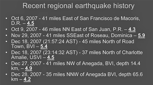
Quakes in this region are common. Noticeable quakes
have been recorded in 1785, 1824, 1844, 1865, 1867,
1913, 1959, 1962, 1970 and 1996. Only 23 tsunamis
were documented in the Region
from 1530-1992.
At 2:50 p.m. the first earthquake struck. Although the logarithmic Richter Scale wasn’t invented until 1934, the shock was estimated at a 7.2-7.5 quake, using the Modified Mercalli Index, a subjective measure of destruction derived in 1902. The quake originated from the Virgin Islands Basin.
Eyewitness Rear Admiral J.S. Palmer observed from the Susquehanna (National Archives Record Group 45 transcribed; and compiled in Mr. Watlington’s book *), “Whilst writing in my cabin, about half past two PM, attention was attracted by a sudden tremor seizing the ship–increasing in intensity, accompanied by a sound resembling the grinding of a vessel upon a rough bottom; then gradually subsiding until it ceased; the whole lasting about two minutes. I recognized it immediately as an earthquake, and looking towards town, saw, from the dust and confusion there had been destruction among its buildings; concluding it was now over, I resumed my occupation, and had been seated about ten minutes, when the report was brought to me, that the sea outside of the harbor had risen, and was coming in, a huge volume–as if to engulf us all. I went on deck, and here the extraordinary spectacle of a heavy wall of sea–some twenty feet in height, apparently distant about three miles, was coming towards the harbor with terrible power. …A small Steamer and sailing vessel, that were trying to get in, were at once engulfed, and never again seen, and the vessels at anchor near the entrance, were lifted from their moorings, and carried onto the rocks to leeward.”
“The sea was now rushing in and receding with great violence, the sunken wrecks were rising, the shipping in the harbor swept from their moorings, were coming into us every few minutes; the small craft in-shore were lifted up and thrown into the streets, and left stranded along the water front…” “At last the water in the bay subsided into a sort of whirlpool…”
“Constant shocks of earthquakes occurred every ten or fifteen minutes and so continued, with more or less severity through the night……The damage on shore has been far more ruinous to the merchants than that occasioned by the late hurricane. The first heavy roller went up into the town swamping the stores finally stranding their goods in unheard of directions.”
Approximately 89 documented shocks took place within a 12 hour period. Hundreds of additional shocks were recounted in the following weeks in the Virgin Islands (Coral Bay’s Moravian brethren kept accounts), Puerto Rico, other Northern Antilles islands, and mainland Mexico. Little Saba was reported temporarily submerged. Mr. Watlington and Ms. Lincoln’s book catalogues documents describing aftershocks that were felt well into 1868, including the St. Croix newspaper Avis’ claims of volcanic eruptions of Mt. Vesuvius from the 14th-21st of November and volcanic eruptions in Iceland.
Ms. Lincoln read an account of well-filled churches after the tsunami, with more religious fervor displayed than after the hurricane. Resumption of work was spotty due to continued after-shocks. Needless to say, the Danish monarchy’s plebiscite was postponed. These natural disasters may have increased U.S. ambivalence towards the transfer, postponing consideration of the Virgin Islands’ purchase until 1917.
Although the loss of material possessions was high, loss of life due to the tsunami itself in comparison with that due to the earlier hurricane and earthquake was modest. That would not be so today. In our tourism and villa boom, an increased amount of GNP-generating activity takes place seaside. We were asked to imagine several 3000-passenger cruise ships at Havensight during a 25’ tsunami. In 1867 there were many people inland and upland; they survived. Today, most Virgin Islanders earn a living nearer the shoreline. Tens of thousands of people are 5-6 minutes tsunami travel time from the 1867 epicenter on a typical shopping day.
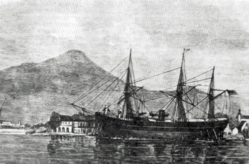
Crew of the high and dry USS Monongahela
helped Frederiksted rebuild afterwards.
Citizens dedicated a Lutheran Churchyard
gravestone to the deceased and wrote a letter
of thanks to Commodore Bissell. Many family
names on that letter are familiar in the Virgin
Islands today.
(Picture source: US Naval Historicfal Center)
This is not to say economic loss would not be great as well. The estimated 8% drop in 1996 VI revenues due to Marilyn and Bertha would be swamped by the revenues lost in a tsunami today.
“Recent tsunamis, particularly the December 24, 2004 disaster in Asia which killed almost 300,000 people, have reawakened interest in an alert system,” he says. But tsunami can be caused by fault ruptures and earthquakes (the most frequent factor), or by underwater landslides and meteor/ asteroid strikes; and tsunami behavior may seem erratic, e.g., a major 1918 tsunami damaging Puerto Rico was barely noticed on St Thomas. This is why a single detection and alert system is so fallible. The 3 DART (Deep-ocean Assessment Reporting of Tsunamis) pressure sensors on the ocean floor that look so reassuring to us on a map are of more use to the US Coastal seismic warning system than to us.
Because there may be a short period of time between a quake you can feel and resultant wave, sometimes only minutes, a local alert or evacuation cannot wait for directions from the government. Mr. Watlington urged us to rely on ourselves and not depend on local 24/7 official responsiveness. The Alaska Tsunami Warning System and the Puerto Rico Seismic Network provide very reliable data crunching for threat identification and assessment, he noted, but if the ground shakes hard enough to knock you down, don’t wait. “Look to the sea, keep looking to the sea, but RUN uphill.”
Mr. Watlington identified possible 2008 ‘local’ tsunami threats from several sources–the VI Basin, the Puerto Rico trench and Loiza amphitheater to our northwest, the Anegada Passage, and the Muertos Trench south of Puerto Rico and Mona Canyon northwest of Puerto Rico. “But,” he advises, “the possibility of a tsunami should cause less concern than the more likely eventuality of a serious hurricane. Those living in elevations accessible to tsunamis (about a dozen raised hands in the audience!) should be more concerned about hurricane storm surge. For tsunamis, they need to identify their own escape paths to higher elevations and then help the community build the best tsunami warning system possible.”
Are on-island “Tsunami Hazard and Evacuation Route” signs in our future? Who is writing the worst case scenario/plan for seaside evacuation in case of major earthquake, or the one for cruise ships or oil tankers? Is there an additional role in mind for that proposed upland school on VINP acreage? Stay tuned. In the meantime, if the ground shakes, forget your Suzuki in the parking lot; head upland.
* Disaster and Disruption in 1867; Hurricane, Earthquake, and Tsunami in the Danish West Indies. Roy A. Watlington and Shirley H. Lincoln. Eastern Caribbean Center, University of the Virgin Islands. 1997.
For additional naval history and pictures, please seehttp://www.history.navy.mil/branches/nhcorg11.htm.
See the related items:
[Natural history]
| Resource | Title | Attributes |
|---|---|---|
| Article | Bay Rum: A Niche of Distinction in VI History | Schulterbrandt, L.D.N., Gail |
| Article | Forest Island | Gibney, Eleanor |
| Article | Soldier Crab Saga | Boulon, Rafe |
| Article | Nineteenth Century Ornithologist at Estate Adrian | Ober, Frederick |
| Article | Report of the Earthquake of 1867 | Housel, Louis van |
| Article | November Rain | Gibney, Eleanor |
| Article | Of Waterfalls and Rock Carvings | deBooy, Theodoor and Faris, John T. |
| Article | Earth Day 2008 on the SJHS Provisions Grounds | Schoonover, Bruce & Swank, Robin |
| Article | Hike to Estate Retreat | Swank, Robin |
| Article | Earthquakes & Tsunamis: Prospects for the Virgin Islands | Watlington, Roy and Lincoln, Shirley |
| Article | Lignum vitae: Beauty, Strength, and the Fallibility of Medicine | Gibney, Eleanor |
| Article | Fever | Gibney, Eleanor |
| Article | Historical Society Installs Plant Signs at Annaberg | Schoonover, Bruce |