Creque Marine Railway, Hassel Island, a Walking Tour
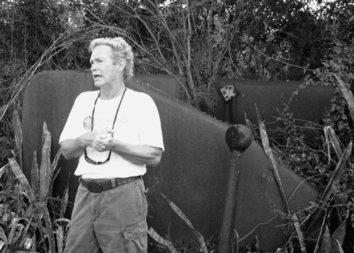
guests join VINP Archaeologist Ken Wild as
he explains Hassel Island’s development
timeline and the story of possibly the oldest
remaining marine railway in the world
(Summarized by Robin Swank)
What enchants us upon landing on Hassel Island’s north shore is the visual impact of nearly intact metal, brick and stone artifacts littering the coastline, visible after the mammoth clean-up effort orchestrated by the St Thomas Historic Trust. It’s true all is in need stabilization; however, we are fortunate to have Hassel Island’s layered history–1000-400BC prehistory, Taino settlement, British occupation, Danish occupation, multi-cultural farming and commercial settlements, US Naval occupation–physically intact.
At the time of ‘slipway’ construction, Hassel acreage was a peninsula of St. Thomas, forming an “orkanhullet,” or hurricane hole, for ships in busy Charlotte Amalie harbor. The protected slipway, called Careening Wharf by the Hazzel family in the early 1800s, joined the Royal Mail Steam Packet Company facilities, 3 coaling docks which accepted coal from the US for distribution, another working marine railway and a floating drydock in servicing vessels at this strategically placed and mostly neutral distribution center for European and US goods. At times the harbor side of the island was almost entirely ‘wharfed,’ Ken reported.
The St Thomas Marine Repair facility was built according to a plan laid out by Mr. Matthew. It opened for commercial use in 1844. The original facility consisted of a steam-powered winch, repair shop, storage buildings, and a residence.
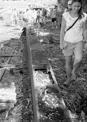
Members walk up the 30’ wide
slipway, an incline on which
the cradle (‘Morton’s Carriage’)
would have traveled to the Home
Building. The rails here are post
1910 vintage and run about 210
feet from the end of the wetdock
to the masonry incline.
Why were the slipway and its attendant careening facilities so successful? St. Thomas was a logical place for a busy commercial harbor. Luther Zabriskie in The United States Virgin Islands Part I; History to 1916, says it well: ”Because of its peculiar geographical position, St. Thomas is the logical distributing centre for goods from Europe or the U.S. destined to any of the islands or to the northern ports of South America. It is located on the direct line of communication between European ports and the entrance to the Panama Canal and in addition is in the path of vessels plying between the Atlantic ports of the two Americas or between the Atlantic and Pacific ports of these two continents… Its location commands the Virgin Passage to the Caribbean Sea, the easternmost gateway to that body of water.” It also probably helped that the islands under Denmark remained neutral territory, that the port was for most of its history a ‘free port’ and that the harbor was well protected.
Throughout its history repair and maintenance remained a constant. In 1854, the St Thomas Tidende reported the marine railway owners had replaced 2½ sections of defective rails in 12 feet of water using a diving bell. In 1867 a cradled ship, Gem of the Sea, toppled over and the company was cited for negligence, noting that the chocks and cradle were worn out or defective. Then during the hurricane the coaling jetty and most of the wharfage was lost, as were the buildings’ roofs.
By 1910 the marine railway failed commercially and it was bought at auction by Henry O. Creque for less than $7,000. Following restoration it reopened as the Creque Marine Railway in 1912.
During WWII the Navy leased the facility and used it for hauling out minesweepers and barges. The deteriorating facility was used intermittently after that. It was purchased in the 1930s by the Paiewonsky family who were acquiring much of the island to provide water for their rum distilleries. Ralph and Isadore Paiewonsky sold their holdings to the Department of the Interior for Park incorporation in 1978.
After our walk through the Slipway, we have lunch at Careening Cove on the island’s eastern shore and take a quick water taxi tour to view several of Hassel Island’s other sites— from Britain’s Napoleonic war-era Fort Shipley which faces west above the Marine Railway to Fort Willoughby (Fort Prince Frederick) which faces east at the other end of Hassel. The ruins of estate houses, the smallpox hospital, the shoreside powder magazine, and the 1917-1931 US Navy Barracks, cookhouses, hospital, and offices that housed 1500 men and represent other layers of physical archaeology just have to await the next trip.
Read more about the history of Hassel Island and the engineering feats and difficulties of the Creque Marine Slipway; view photos and line drawings prepared by the organizations at Historic American Building Survey (HABS) and Historic American Engineering Record (HAER). Also see this Hassel Island timelinefrom Fred Gjessing’s “1992 A Cultural Resources Assessment of Hassel Island.” Thank you, Ken, and also thanks to HAER, of the Heritage Conservation and Recreation Service, for our historic information and an inspirational field trip.

Equipment to haul a cradled ship includes_minified a 23 foot long wrought iron rods, iron chains, huge ground
deadbolts to secure the cradle, reduction gears, winch and flywheel. “Greenheart” cradles of various
sizes, sunk with ballast so a ship could float onto them, accommodated ships up to 156 feet long.
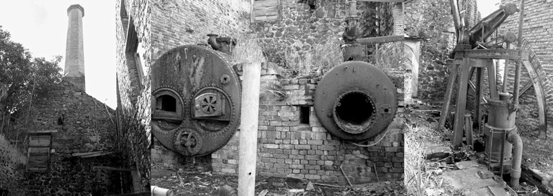
The winch and walking beam engine powering the winch, built in Hamburg by the Bolton Co. in the
1840s, are well preserved. Bolton’s cast iron steam engines were known for durability and silence. Still
on-site are the original wood fed boilers that drove the steam engine and the smokestack. The engine
technology looks familiar, but, says Ken, “it’s a little larger than the one Bogie kept functioning on the
‘African Queen’.”
A dive bell is mentioned in conjunction with
repairing rails underwater in 1845; we saw two
onsite.
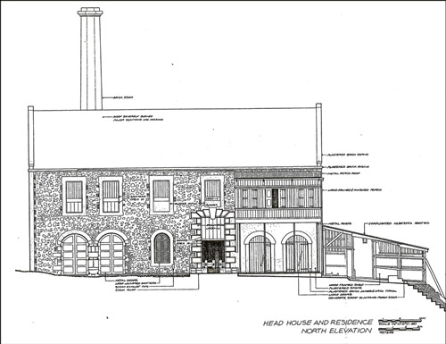
Head House and Residence of the Creque
Marine Railway, schematic completed by
HAER as part of the VI Recording Project
in 1977. Behind the house sits a prefabricated
cast iron cistern on masonry piers that provided
gravity fed water to the boilers. A tank on the
south side of the powerhouse was filled from
the cistern by hand pump, supplying water to
the living quarters.
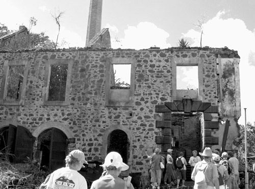
The original Head House and Residence has a
brownstone entryway to the winchroom. The
metal doors at left enclose 2 cast iron boilers
which served the steam engine in parallel after
1912. The roof is missing, as is the wood-framed
right hand portion of the structure, which as
the 2 story residence, occupied originally by the
Superintendent for the St. Thomas Marine
Repair Slip, and from 1910 until the mid 1940s
by Mr. Creque and his descendents.